Origin of the Name of the District
The district is named after Jalandhar, a demon king, who finds a mention in the Puranas and Mahabharta. According to another legend, Jalandhar was the capital of the kingdom of lav, son of Rama. According to yet another version Jalandhar is said to have derived its name from the vernacular term `Jalandhar’ means area inside the water, i.e. tract laying between the two rivers Satluj and Beas, still another name of Jalandhar had been Trigartta, as it was waters by three rivers, Satluj, Beas and Ravi.
Jalandhar is located on the intensively irrigated plain between the Beas and Sutlej rivers. The city, which has major road and rail connections, is a market for agricultural products. Manufactures include textiles, leather goods, wood products, and sporting goods. Jalandhar was the capital of Punjab from India's independence (1947) until Chandigarh was built in 1953.Jalandhar is situated at 710 31’ East and 300 33’ North at a distance of 146 kms from state capital Chandigarh. It is at a distance of 350 Kms from Delhi on Delhi-Amritsar Highway. It is surrounded by Ludhiana district in East, Kapurthala in West, Hosiharpur in North and Ferozepur in South. It is well connected by road and train. Nearest Airport is RajaSansi Airport, Amritsar at a distance of 90 kms.
Total Area and Population of the District
According to 2001 Census provisional, the area of Jalandhar District is 3,401 sq. km According to 2001 Census provisional figures, the total population of the district was 19,53,508 persons (10,26,535 males and 9,26,973 Females).
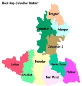
Administrative Division of the District
The Jalandhar District consist of 5 tehsils/subdivisions viz. Jalandhar-I, Jalandhar II, Nakodar, Phillaur and Shahkot. Besides, there are 5 sub-tehsils, viz. Adampur, Bhogpur, Kartarpur, Goryan and Nurmahal. The district is divided into 10 development blocks, viz, Jalandhar East, Jalandhar West, Bhogpur, Adampur, Nakodar, Shahkot, Phillaur, Nurmahal, Lohian and Rurka Kalan. According to 2000-2001 figures of District Statistical Office, the district has 956 inhabited villages.
The climate of this district is on the whole dry except during the brief south-west monsoon season. The year may be divided into four seasons. The cold season is from the middle of November to early part of March. The succeeding period upto the end of June in the summer season, July, August and first half of September constitute the South-West monsoon season. The period from middle September to the middle of November is the post monsoon or transition period. Although tehsil Phagwara is in the Kapurthala District, for the description of climate the same has been included in the Jalandhar district.
The average annual rainfall in the district is 703.0 mm. The rainfall in the district in general increases from the south-west towards the north-east and varies from 551.3 mm at Nakodar to 892.3 mm at Adampur (Aera-obsy). About 70 per cent of the annual normal rainfall in the district is received during the period July to September, July being the rainiest month. Some rainfall is received mostly as thunder showers in June and in association with passing western disturbances in the cold season. The variation in the rainfall from year to year in the district is appreciable. In the 80 year, 1901 to 1980, the highest annual rainfall amounting to 181 per cent of the normal occurred in 1917. The lowest annual rainfall which was 55 per cent of the normal occurred in the year 1905. In the same period, the annual rainfall in the district was less than 80 per cent of the normal in 22 years.
On an average, there are 36 rainy days (i.e. days with rainfall of 2.5 mm or more) in a year in the district. The number varies from 30 at Phagwara to 45 at Adampur (Aera-obsy). The heaviest rainfall in 24 hours recorded at any station in the district was 304.8 mm at Jalandhar on 18 August 1878.
There is a meteorological observation in the District of Jalandhar. But it has started functioning very recently. So description follows is based on the records of the observatories in the neighboring district where similar climate conditions prevail. After February, temperature begin to rise rapidly. June is generally the hottest month with the mean daily temperature at about 41oC and the mean daily minimum at about 27oC. Scorching dust laden winds blow on many days in the summer season and the day temperatures on individual days may reach above 450C. Afternoon thundershowers which occur on some days during the summer bring welcome relief though only temporarily. With the onset of monsoon by about the end of June or early in July, the day temperature drop down appreciably. But the nights continue to be a warm during the summer. Due to increase moisture in the monsoon air, the weather is often sultry and uncomfortable, in between these rains. After about mid-September when the monsoon withdraws temperatures decrease, the drop in the night temperature being rapid. January is generally the coldest month with the mean daily maximum temperature at about 19oC and the mean daily minimum at about 6oC. During the winter season. Cold waves effect the district in the rear of western disturbances and the minimum temperature occasionally drops down below the freezing point of water.
During the brief south-west monsoon months and for spells of a day or two in association with the passing western disturbances high humidity prevails in the district. In the rest of the year, the humidity is low. The driest port of the year is the summer season when in the afternoons the relative humidity is 30 percent or less.
The skies are heavily clouded and over cast on a few days during the south-west monsoon and for spells of a day or two in association with passing western disturbances during the cold season. During the rest of the year, the skies are mostly clear or lightly clouded.
Winds are generally light in the district. In the south-west monsoon season, winds from direction, between north-east and south-east, are common but on many days in the afternoons westerly to north-westerly winds predominate, except in the latter half of summer, when easterlies and south easterlies blow on some days.
Provisional figures of Jalandhar District & Tehsils at a glance
T – Total R – Rural U - Urban Municipal Corporations/Councils/Nagar Panchyats
| |||||||||||||||||||||||||||||||||||||||||||||||||||||||||||||||||||||||||||||||||||||||||||||||||||||||||||||||||||||||||||||||||||||||||||||||||||||||||||||||||||||||||||||||||||||||||||||||||||||||||||||||||||||||||||||||||||||||||||||||||||||||||||||||||||||||||||||||||||||||||||||||||||||||||||||||||||||||||||||||||||||||||||||||||||||||||||||||||||||||||||||||||||||||||||||||||||||||||||||||||||||||||||||||||||